ATPL(A) 033 Flight Planning & MonitoringRevision notes and practice questions
This subject follows the real order of a preparation: choose a route, compute the fuel, check the documentation, file a flight plan, then monitor the execution.
- 31 pages
- 311 questions
- €11.90 once
What the 033 notes cover
Written on the EASA Learning Objectives.
Checked against the primary texts.
An A4 PDF and a screen edition.
- Part 1033 02
IFR planning
Route selection, minimum altitudes, flight levels and the choice of alternate aerodromes.
- Part 2033 03
Fuel
The fuel/energy scheme of Regulation 2021/1296, every element, the permitted reductions and the special cases.
- Part 3033 04
Pre-flight preparation
NOTAM briefing, meteorological briefing, point of equal time and point of safe return.
- Part 4033 05
The ICAO flight plan
Every item of the form, the repetitive flight plan, filing deadlines and procedures.
- Part 5033 06
Monitoring and re-planning
In-flight monitoring, deviations to report, in-flight fuel management and re-planning.
Exam traps in 033 Flight Planning & Monitoring
A sample from Appendix B.
The full list is in the notes.
Exam trap
- The semi-circular rule applies to the magnetic track, never to the heading.
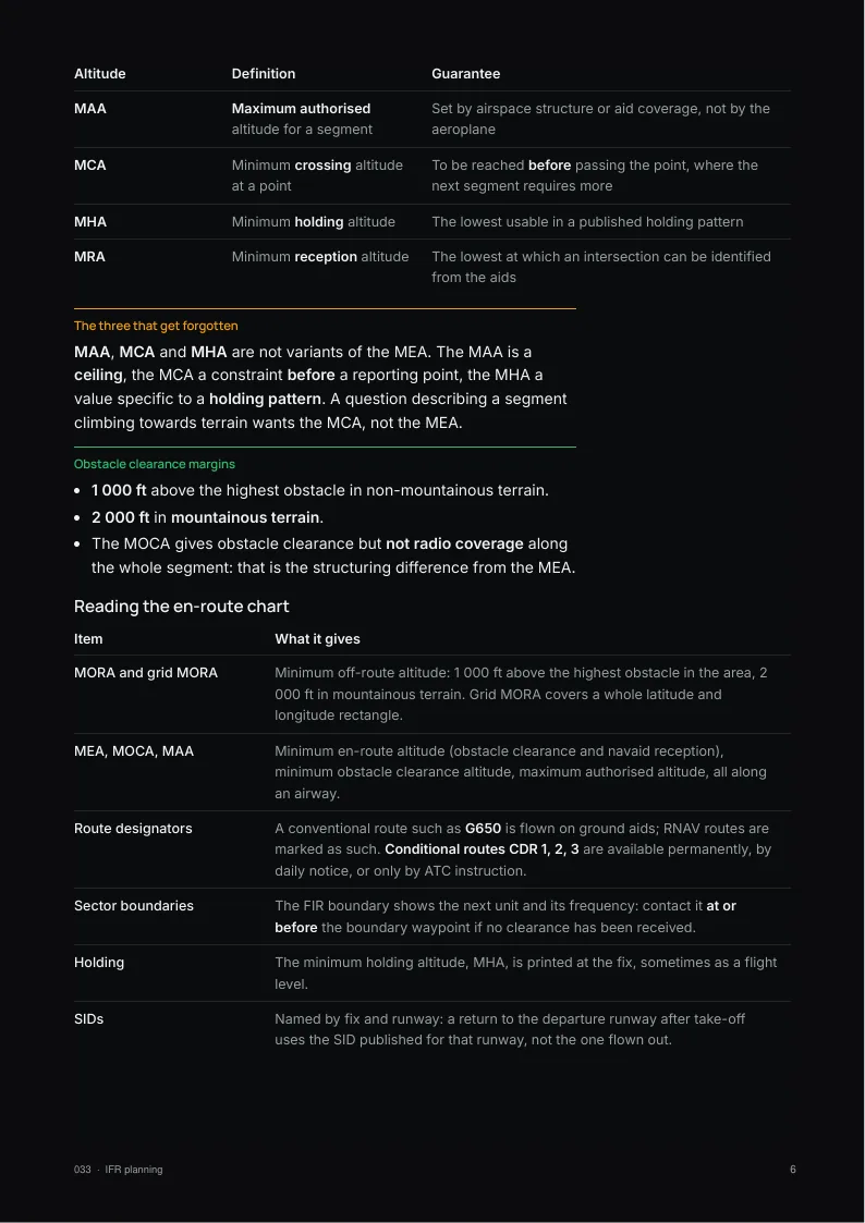
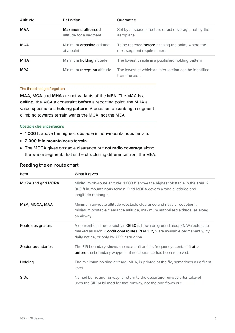
- The MOCA guarantees obstacle clearance but not radio coverage; it is the MEA that guarantees both.
- With a low QNH, a flight level is lower than the corresponding altitude.
- RVSM stops at FL410 inclusive: above it, separation returns to 2 000 ft.
- Final reserve is computed at the estimated arrival mass at the alternate, not at take-off mass.
- It is computed above the alternate, not above the destination.
The EASA 033 paper: 42 questions in 2 h. The exam rules →
A student asked: Where do I start with ATPL Flight Planning (033)?
Ten free 033 Flight Planning & Monitoring questions
No account needed.
Pick an answer and the explanation opens.
The notes come with 1 month of all 311 questions and the mock exams.
1A performance class B aeroplane is to fly a Commercial Air Transport flight to an isolated destination aerodrome. Using the data below, calculate the minimum fuel (to the nearest 10 kg) that must remain on arrival overhead the isolated aerodrome.
Flight time: 2 hours 45 minutes
Top of climb to top of descent: 2 hours
Normal cruise fuel consumption: 540 kg per hourShow the answer
Answer B. For a CAT flight to an isolated aerodrome with a reciprocating-engine class B aeroplane, the fuel on arrival overhead must cover 45 minutes plus 15% of the planned cruise time, or 2 hours, whichever is less.
45 min + 15% x 120 min = 63 min, well under 2 hours.
Fuel = 63/60 x 540 = 567 kg, about 570 kg. Using the full 2 hours gives the 1080 kg trap, and basing the 15% on the whole 2 h 45 min flight time gives the 630 kg figure.2The minimum climb gradient required for obstacle clearance is 4%. The TAS for best rate of climb is 230 kt. With a tailwind of 15 kt, what is the minimum rate of climb that must be achieved?
Show the answer
Answer B. The gradient is measured over the ground, so the ground speed applies: 230 + 15 = 245 kt. At 4% the aircraft must gain 4 ft for every 100 ft travelled over the ground, and 245 kt is 245 × 101.3 ≈ 24 820 ft/min along the ground, so the rate of climb needed is 24 820 × 0.04 ≈ 993 ft/min, about 995 ft/min. Using the TAS of 230 kt instead gives about 935 ft/min, which would not guarantee the gradient with a tailwind.
3For a class B multi-engine aeroplane, what is the range calculation based on?
Show the answer
Answer C. Class B range charts are entered with the cruise pressure altitude and the chosen power setting, which together fix the TAS and the fuel flow. They are drawn for a stated weight and give still-air range, with a separate allowance for the ISA deviation. They are therefore not valid for every weight or temperature, and they give an air range, not a ground range including wind.
4Given:
Distance from departure to destination: 1345 NM
GS out: 480 kt
GS home: 360 kt
What is the time to the PET from the departure point?Show the answer
Answer D. The distance to the point of equal time is D × H / (O + H) = 1345 × 360 / (480 + 360) ≈ 576 NM from departure. It is flown at the outbound groundspeed, so the time is 576 / 480 = 1.2 h, or 72 minutes. Dividing by the homebound groundspeed instead gives 96 minutes.
5In Item 15 of an ATS flight plan, how should you indicate that you will overfly waypoint TANGO at 350 kt and flight level 280?
Show the answer
Answer C. A change of speed or level at a point is written as the point, an oblique stroke, then the speed followed by the level with no space. Speed in knots is N plus four figures (N0350) and a flight level is F plus three figures (F280), giving TANGO/N0350F280. K would mean km/h, FL is not a valid prefix, and the level can never come before the speed.
6Using the data below, what is the ground speed?
TAS: 150 kt
Track: 090°
Wind: 050°/46 ktShow the answer
Answer A. The wind from 050° is 40° off the 090° track, from ahead and to the left: headwind = 46 × cos 40° = 35 kt and crosswind = 46 × sin 40° = 30 kt. The drift correction is asin(30 / 150) ≈ 11°, so GS = 150 × cos 11° − 35 = 147 − 35 = 112 kt. Answers above 150 kt treat the headwind as a tailwind.
7At 14:58 ATC instructs you to fly direct to OAL VOR/DME and reduce speed to M 0.76 for traffic separation. Using the data below, what is the revised ETA at OAL?
Distance to OAL via the flight-planned route: 120 NM
Direct distance to OAL: 90 NM
Magnetic track to OAL from present position: 053°
Variation: 2°E
Pre-flight planned Mach: 0.80
Forecast wind: 350°/40 kt
Actual wind: 045°/65 kt
OAT: -35°C
ETA at OAL: 15:08Show the answer
Answer A. At −35°C the speed of sound is about 601 kt, so M 0.76 is a TAS of 457 kt. The track to OAL is 053°M, i.e. 055°T, and the actual wind from 045° at 65 kt is almost on the nose: about 64 kt of headwind, giving a GS of about 393 kt. The 90 NM direct distance takes 90 / 393 × 60 ≈ 14 min, so the revised ETA is 14:58 + 0:14 = 15:12. The planned Mach, the forecast wind and the flight-planned distance are no longer relevant.
8Can a road junction or a railway line be entered as a waypoint in a Global Navigation Satellite System (GNSS) flight plan?
Show the answer
Answer A. GNSS navigators allow user-defined waypoints, so a road junction or railway feature can be entered by typing its latitude and longitude, or by defining it relative to an existing waypoint in the database (place/bearing/distance). No authority permission is needed, and there is no requirement to build it from an aerodrome reference point.
9Given:
True course (TC): 017°
Wind: 160°/25 kt
True airspeed (TAS): 180 kt
Find the wind correction angle (WCA) and the ground speed (GS).Show the answer
Answer A. The wind from 160° is 143° off the true course of 017°, coming from behind and to the right. The crosswind is 25 × sin 143° = 15 kt from the right, so the wind correction angle is asin(15/180) ≈ 5° to the right, +5°. The tailwind is 25 × cos 37° = 20 kt, so the ground speed is 180 × cos 5° + 20 ≈ 199 kt. 161 kt treats the tailwind as a headwind, and -5° corrects the wrong way.
10What is the difference between an RNAV STAR and an RNAV STAR overlay?
Show the answer
Answer B. An RNAV STAR overlay is a conventional arrival, defined by ground-based aids, that has been coded so that it can be flown with area navigation (GNSS or the FMS) along exactly the same path. It is therefore neither longer, shorter nor different from the conventional procedure. A pure RNAV STAR, in contrast, is designed for area navigation from the start and need not match any conventional route.
Keep practising.
The 033 notes come with 1 month of its 311 questions.
The pack: the notes of all thirteen subjects, with 2 months of all 6,295 questions.
Get 033 Flight Planning & Monitoring
Pay once, no subscription.
Practise longer with its question bank.
The notes
€11.90 once
+ 1 month of its questions
PDF and screen edition, yours for life.
Updates included for 1 year.3 months of 033 questions
€39 once
€13.00 / month
All 311 questions with explanations and the mock exams, for this subject only. Questions only: the notes are not included.
The other subjects
- 010Air Law28 pages547 questions€7.90
- 021Airframe, Systems, Powerplant50 pages551 questions€19.90
- 022Instrumentation29 pages568 questions€11.90
- 031Mass & Balance30 pages328 questions€11.90
- 032Performance25 pages461 questions€7.90
- 040Human Performance46 pages578 questions€19.90
- 050Meteorology43 pages447 questions€19.90
- 061General Navigation49 pages417 questions€19.90
- 062Radio Navigation29 pages512 questions€11.90
- 070Operational Procedures40 pages531 questions€15.90
- 081Principles of Flight39 pages516 questions€15.90
- 090Communications27 pages528 questions€7.90