PPL(A) 050 MeteorologyRevision notes and practice questions
Meteorology decides whether a VFR flight can start, continue or must turn back.
The French DGAC paper has 20 questions; 75 %, that is 15 correct answers, is a pass.
Learn the chains of cause and effect, practise the altimetry sums, then decode real METAR and TAF every day.
- 24 pages
- 80 questions
- €6.90 once
French DGAC exam: 20 questions, 75 % to pass (15 correct).
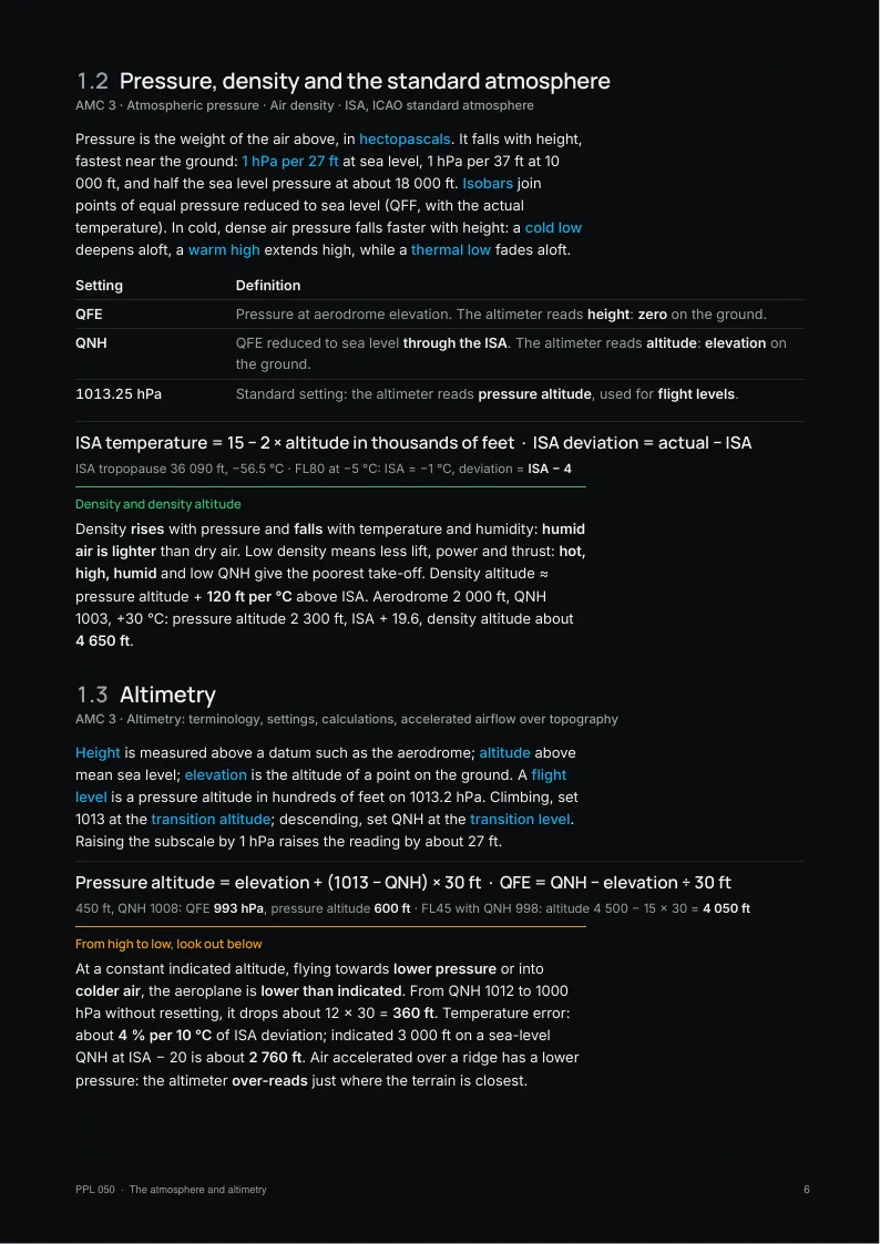
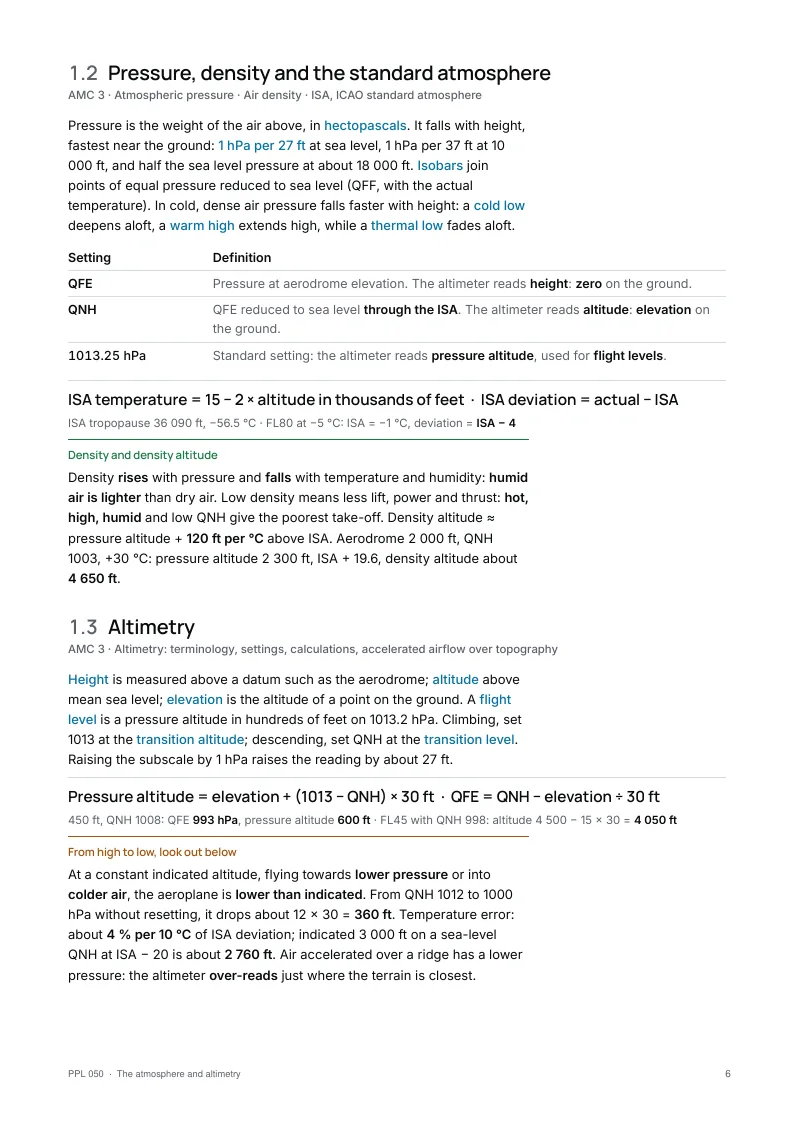
What the PPL 050 notes cover
Written on the EASA PPL(A) syllabus.
Checked against the primary texts.
An A4 PDF and a screen edition.
- Part 1
The atmosphere and altimetry
Layers, temperature, pressure, density, the standard atmosphere, QNH, QFE and 1013.
- Part 2
Wind
Pressure gradient, Coriolis, Buys Ballot, friction, breezes, föhn and mountain waves.
- Part 3
Humidity, stability and clouds
Dew point, lapse rates, stability, cloud base, the ten cloud genera.
- Part 4
Precipitation and visibility
Rain, showers, freezing rain, hail; fog, mist and haze.
- Part 5
Air masses, fronts, pressure systems
The weather of a passing depression, anticyclones and typical European situations.
- Part 6
Flight hazards
Airframe and carburettor icing, turbulence, wind shear, thunderstorms.
- Part 7
Meteorological information
METAR, TAF, SIGMET, AIRMET, GAMET, charts, VOLMET, ATIS and the briefing.
Exam traps in PPL 050 Meteorology
A sample from Appendix B.
The full list is in the notes.
Exam trap
- The tropopause is higher over the equator, not over the poles.
- QNH reads elevation on the ground, QFE reads zero. QFF is for charts only.
- Towards low pressure or cold air at constant indicated altitude: you are lower than indicated.
- Coriolis only deflects; it is zero at the equator.
- Surface wind is backed and weaker; by day it increases and veers, at night it decreases and backs.
- Sea breeze by day from the sea; katabatic wind at night down the slope.
Ten free PPL 050 Meteorology questions
No account needed.
Pick an answer and the explanation opens.
The notes come with 1 month of all 80 questions and the mock exams.
1Which statement about the composition of the atmosphere is correct?
Show the answer
Answer A. Dry air contains about 78 % nitrogen, 21 % oxygen and 1 % other gases, in proportions that stay the same to very high altitude. Water vapour is the variable part, from almost 0 to about 4 % by volume, and it makes the weather. Hypoxia comes from the fall in pressure, and therefore in the partial pressure of oxygen, not from a lower percentage of oxygen.
2Which statements about altimeter settings are correct?
1. With QFE set, the altimeter reads height above the aerodrome.
2. With QNH set, the altimeter reads the aerodrome elevation when the aeroplane is on the ground.
3. With 1013 hPa set, the altimeter reads a flight level, that is a pressure altitude.
4. QNH is the pressure measured at the aerodrome reference level.Show the answer
Answer D. QFE is the pressure at aerodrome level, so with QFE set the altimeter reads zero on the ground and height above the aerodrome in flight. QNH is the QFE reduced to mean sea level with the standard atmosphere, so with QNH set the altimeter reads altitude, and elevation on the ground. With 1013 hPa set, it reads pressure altitude, expressed as a flight level. Statement 4 describes QFE, not QNH, which is the classic confusion.
3Which statement about the geostrophic wind is correct?
Show the answer
Answer B. The pressure gradient force is the only driving force: it pushes air from high to low pressure, perpendicular to the isobars. The Coriolis force, due to the rotation of the Earth, only deflects the moving air, to the right in the northern hemisphere and to the left in the southern hemisphere. Above the friction layer, with straight isobars, the two forces balance and the wind blows parallel to the isobars: this is the geostrophic wind. Coriolis never creates wind on its own.
4On a summer afternoon at an aerodrome, the surface temperature is +22 °C and the dew point +14 °C. Cumulus is starting to form. Using the usual rule of thumb, at about what height above the aerodrome is the cumulus base?
Show the answer
Answer C. A rising unsaturated parcel cools at about 3 °C per 1 000 ft while its dew point falls at about 0.5 °C per 1 000 ft, so the spread closes at 2.5 °C per 1 000 ft, that is 400 ft per °C. The spread is 22 − 14 = 8 °C, so the base is 8 × 400 = 3 200 ft above the ground. 2 700 ft comes from dividing the spread by the dry adiabatic rate alone, which forgets that the dew point also falls as the parcel rises.
5Precipitation at an aerodrome starts suddenly, is heavy for about 10 minutes, then stops abruptly and the sky clears between the cells. Which cloud is most likely producing it?
Show the answer
Answer D. Precipitation that starts and stops abruptly and changes quickly in intensity is a shower, which falls from cumuliform cloud: cumulus congestus or cumulonimbus. Nimbostratus gives continuous rain or snow over a wide area and altostratus lighter continuous precipitation. Stratus produces at most drizzle, very fine drops that reduce the visibility.
6In winter, an air mass that has travelled from the subtropical Atlantic near the Azores reaches western France. What weather does it typically bring?
Show the answer
Answer B. This is tropical maritime air: mild and very moist. Over the colder winter surface it is cooled from below, which makes it stable in the lower layers, so it brings stratus, drizzle, poor visibility and advection fog. Showers with good visibility are typical of polar maritime air, heated from below on its way south. Clear, very cold and dry weather comes with polar continental air from the east, and hot dusty air with tropical continental air from North Africa.
7How does the air circulate around a depression at the surface in the northern hemisphere?
Show the answer
Answer A. In the northern hemisphere the wind blows anticlockwise around a low, with low pressure on the left when the wind is behind you (Buys-Ballot's law). Friction near the surface makes the wind cross the isobars towards the low pressure, so the air converges at the centre and is forced to rise, which gives cloud and precipitation. Around an anticyclone the circulation is clockwise and the surface air diverges outwards, fed by sinking air.
8Moist air at sea level, temperature 15 °C, is forced over a mountain range by the wind. It becomes saturated at 3 000 ft, stays saturated and loses its water as precipitation up to the crest at 9 000 ft, then descends to sea level on the lee side. Using 3 °C per 1 000 ft for dry air and 1.5 °C per 1 000 ft for saturated air, what is the temperature at sea level on the lee side?
Show the answer
Answer B. Up to 3 000 ft the air cools at the dry rate: 15 − 3 × 3 = 6 °C. From 3 000 to 9 000 ft it cools at the saturated rate: 6 − 6 × 1.5 = −3 °C at the crest. Having lost its water, it descends at the dry rate: −3 + 9 × 3 = 24 °C. This is the föhn effect: the lee side is warmer and drier than the windward side at the same level, and 15 °C would only be found if no condensation took place.
9In which of the following conditions is the risk of airframe icing greatest for a light aeroplane?
Show the answer
Answer C. Structural icing needs two conditions at the same time: supercooled liquid water droplets and an airframe at or below 0 °C. Cumulus cloud just below 0 °C, roughly 0 to −10 °C, holds large and plentiful supercooled droplets, so the risk is high. Clear air holds no liquid water, cirrus at −45 °C is made of ice crystals that do not stick, and rain at +5 °C does not freeze on a normal airframe.
10Read the following METAR:
LFMN 151330Z 22012G24KT 180V250 8000 -SHRA FEW020 SCT035CB BKN080 22/16 Q1012 NOSIG
What are the reported wind and visibility?Show the answer
Answer A. In a METAR the wind direction is given in degrees true, followed by the mean speed and, after G, the maximum gust speed: 22012G24KT means 220° at 12 kt with gusts to 24 kt, not 12 + 24 kt. The group 180V250 shows the direction varying between these two values. Visibility is in metres, so 8000 is 8 km; the magnetic wind is the one given by ATIS and ATC for take-off and landing.
Keep practising.
The PPL 050 notes come with 1 month of its 80 questions.
The PPL pack: the notes of all nine subjects, with 2 months of all 698 questions.
Get PPL 050 Meteorology
Pay once, no subscription.
Practise longer with its question bank.
The notes
€6.90 once
+ 1 month of its questions
PDF and screen edition, yours for life.
Updates included for 1 year.3 months of PPL 050 questions
€19 once
€6.33 / month
All 80 questions with explanations and the mock exams, for this subject only. Questions only: the notes are not included.
The other PPL subjects
- 010Air Law24 pages80 questions€6.90
- 020Aircraft General Knowledge24 pages80 questions€6.90
- 030Flight Performance and Planning22 pages80 questions€6.90
- 040Human Performance20 pages80 questions€6.90
- 060Navigation24 pages80 questions€6.90
- 070Operational Procedures19 pages79 questions€6.90
- 080Principles of Flight21 pages80 questions€6.90
- 090Communications22 pages59 questions€6.90